
Theodore Roosevelt Dam
Introduction
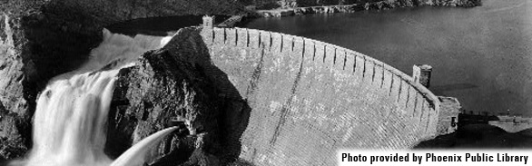
When Theodore Roosevelt Dam was completed in 1911, it became the world’s tallest masonry dam, creating the world’s largest artificial lake. This monumental structure represented an unparalleled success for the Bureau of Reclamation, an agency formed under the Reclamation Act, signed into law by President Theodore Roosevelt in 1902. The Act established Bureau of Reclamation to provide irrigation and aid settlement in the western territories and states. Besieged by drought, Arizona ranchers and farmers sought a water storage system that would sustain them during dry years. Settlement of Central Arizona, with its large-scale irrigation and agricultural development, would not have been possible without the vast reservoir and hydroelectric power supplied by the dam. Roosevelt remains the largest and most visible of four dams maintained by the Salt River Project (SRP), established in 1909.
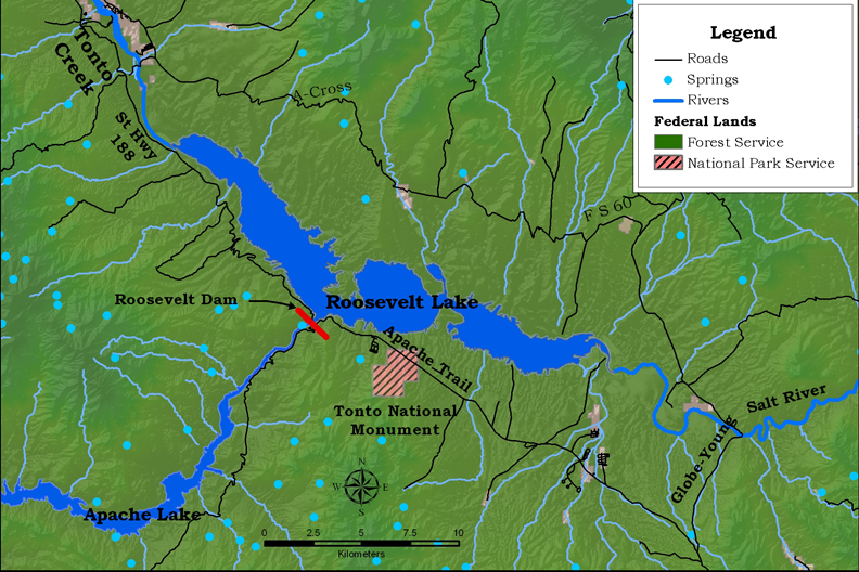 Theodore Roosevelt Dam impounds water from the Salt River northeast of Phoenix, Arizona. Originally known as “Salt River Dam #1,” it was re-christened in 1959 in honor of President Roosevelt, who dedicated the original structure. Following a massive expansion project completed in 1996, the reservoir at full capacity contains over 1.6 million acre-feet of water (this would cover 1.6 million acres, one foot deep). The largest body of water entirely contained within the state of Arizona, the reservoir occupies approximately 22 miles of the original Salt River channel and much of the southern portion of the Tonto Basin between the Sierra Ancha, Mazatzal, and Superstition Mountains.
A popular recreation spot for boating, camping and fishing within the Tonto National Forest, the reservoir is periodically stocked with a variety of game fish including crappie, catfish, and bass. Several trails offer hiking opportunities in the area. The Arizona Trail crosses the Salt River on the Arizona State Route 188 bridge northeast of the dam. This 800-mile trail extends across Arizona from Mexico to Utah. Roosevelt Lake is only 4 miles from Tonto National Monument, where cliff dwellings date back to the thirteenth century. Some monument trails offer views of Roosevelt Lake.
Engineering and Construction
Arthur Powell Davis, nephew to Major John Wesley Powell, described plans for the dam site in “Water Storage on the Salt River, Arizona,” a document submitted to the Bureau of Reclamation in 1903. His plans called for construction of a gravity arch dam, a design that relies on the dam’s own weight and the compressive forces of the arch to retain water. The unique architecture of Roosevelt Dam, with Mycenaean Greek influence, was the largest cyclopean masonry dam in the world, employing enormous blocks of unfinished stone. Cement plants, roads and other infrastructure were built, prior to beginning construction on the huge project.
Construction of Roosevelt Dam began in 1903 in the narrow canyon below the confluence of the Salt River and Tonto Creek. Two 1,200-foot long cableways delivered massive blocks of sandstone and limestone obtained from nearby quarries. These cableways could be moved horizontally and vertically, supporting buckets as heavy as 10 tons. Construction workers used wooden derricks to place the mortar and stone, then tamped down the blocks, filling vertical gaps with concrete and spalls. After waiting several days, keeping the masonry wet to ensure it set properly, they could add another layer. In 1905, a devastating series of floods delayed the project. Despite this and other setbacks, construction was completed on February, 5, 1911 at a cost of $10 million. The structure contained 344,000 cubic yards of masonry and enough steel to reach from Phoenix to Denver.
Major modifications began in 1989 after engineers determined that the probable maximum flood was significantly greater than the dam was originally designed to withstand. Also the structure could fail in the event of a “maximum credible earthquake.” In January 1993, prior to completion of the modifications, record rainfall produced a peak inflow of 140,000 cubic feet per second (cfs) to the reservoir, resulting in overtopping of the left abutment cofferdam. Water poured through a partially constructed spillway and onto the powerhouse below, causing damage and a six-month delay. Eight years of construction added 450,000 cubic yards of concrete and 840 miles of reinforcing steel, and raised the height of the dam from 280 to 357 feet. The final cost of modifications was $430 million—43 times the original cost.
Human History
Today management of Roosevelt Dam by the Salt River Project involves both the Salt River Project Agricultural Improvement and Power District, a political subdivision of the state of Arizona, and the Salt River Valley Water Users' Association. This private corporation, established in 1903, now supplies electricity and water to a service area of about 240,000 acres across Maricopa, Gila, and Pinal Counties in central Arizona.
On May 23, 1963, the Secretary of Interior Stewart Udall designated Roosevelt Dam as a National Historic Landmark—a significant location that illustrates the heritage of the United States. This designation was withdrawn on March 10, 1999 after the safety modifications permanently altered the “integrity of design, materials, workmanship, feeling, or association.” The National Register of Historic Places continues to list the Theodore Roosevelt Dam National Register District and resources relevant to the dam’s construction while excluding the dam itself as a “noncontributing structure.”
When the safety modifications began, the Bureau of Reclamation sponsored a series of archaeological surveys in the Roosevelt Dam area in accordance with the National Historic Preservation Act. During an 8-year project initiated in 1989, archaeologists discovered School House Mound, a massive 115-room complex believed to be the economic center of the Tonto Basin until the 1400s.
Conservation
In the summer months, populations of federally endangered willow flycatchers migrate to central Arizona to nest. These birds build their nests near water, low in shrubs and trees where they are vulnerable to fluctuating water levels. Years of drought have lowered the water level in all of the Salt River dams. This has allowed critical habitat to extend into areas historically submerged by the Roosevelt Lake, which supports one of the largest breeding populations in Arizona. Reservoir levels have been capped to avoid inundating flycatcher nesting sites, placing the flycatcher in direct competition with human water resources. This creates a difficult situation for dam managers who must balance Arizona’s water needs with a federal mandate to preserve endangered species.
A number of other dam management practices have changed since the Endangered Species Act was passed by the United States Congress in 1973. SRP’s Avian Protection Program, dedicated to preserving the native wildlife and habitat of species of the southwest while serving the needs of growing communities, works in cooperation with several government agencies including the Arizona Game and Fish Department and the U.S. Fish and Wildlife Service. They also have formed partnerships with nonprofit organizations such as the Southwestern Bald Eagle Management Committee and the Peregrine Fund. The creation of Tonto Creek Riparian Unit limits grazing in certain areas and provides further protection of nesting habitat.
Contributing Writers
Kim Whitley and Jeri Ledbetter.
Photo provided by: Phoenix Public Library.
Links
Visitation
AmericanSouthwest.net
Tonto National Forest Recreation
Dam Operation
Bureau of Reclamation: Theodore Roosevelt Dam
SRP Water Operations: Theodore Roosevelt Dam
History
Withdrawal of Roosevelt Dam: National Historic Landmarks Program (NHL)
Conservation
Arizona Game and Fish: Southwestern Willow Flycatcher
Bibliography
- U.S. Fish and Wildlife Service. 2005. Designation of Critical Habitat for the Southwestern Willow Flycatcher: Final Environmental Assessment. http://www.nps.gov/nhl/DOE_dedesignations/Roosevelt.htm
- Zarbin, Earl A. 1984. Roosevelt Dam: a history to 1911. Salt River Project.