Ciénega Creek Natural Preserve
Introduction
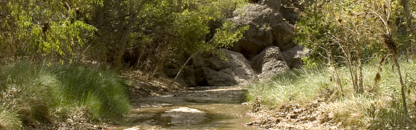
 Each day, traveling at 75 miles an hour on Interstate 10 south of Tucson, thousands of motorists pass over a bridge spanning a typically dry wash. The small sign marking Ciénega Creek receives little notice. The travelers are unaware that only a short distance away is an ecological treasure, and one of the most intact riparian areas in southern Arizona. This unexpected landscape, with quiet pools, seeps, and springs shaded with cottonwood, willow and high cliffs, supports exceptional biodiversity.
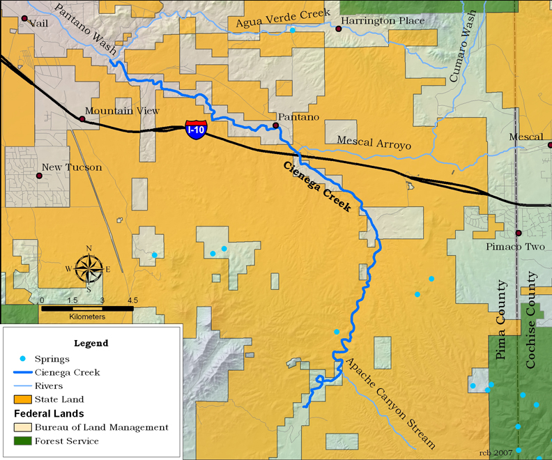
Much of upper Ciénega Creek flows through the Las Ciénegas Natural Conservation Area, managed by the U.S. Bureau of Land Management (BLM). In 1986, the Pima County Board of Supervisors established the Ciénega Creek Natural Preserve, which protects over 12 miles of the lower creek. The creek’s flow is perennial through roughly half of this preserve.
Ciénega Creek lies within the Basin and Range region of southern Arizona. The drainage originates in the Canelo Hills and continues roughly 50 miles toward the northwest where it becomes Pantano Wash. From its origin in the Canelo Hills, Ciénega Creek flows northwesterly through the upper Ciénega basin, a wide alluvial valley separating the Northern Santa Rita and Empire Mountains to the west and Whetstone Mountains to the east. A bedrock high, called the “Narrows,” serves as a hydrologic barrier dividing the upper and lower basins, and is characterized by riparian vegetation and perennial flow. Ciénega Creek then continues northward through the lower alluvial basin until it bends west/northwest in the vicinity of Anderson and Wakefield Canyons. After crossing I-10, Ciénega Creek again crosses a bedrock high, and once more, the flow becomes perennial. In these stretches, groundwater is forced upward through faults in the bedrock from aquifers near the surface.
Ecological Importance
Ciénega Creek Natural Preserve is noted for outstanding quality and variety of natural resources. The riparian environment, a conservation resource equal to any other in the region, rivals that which existed in the Tucson area before 1900. The riparian landscape within the preserve is notable, due to its high biodiversity that is becoming increasingly scarce in Arizona. The preserve is located within a transitional zone between the Sonoran and Chihuahuan Deserts, and exhibits some of the features of each region.
The creek supports outstanding examples of cottonwood-willow gallery forest and mesquite bosque. These are home to bird species that have become rare through loss of riparian habitats, including the Southwestern willow flycatcher, Yellow-billed cuckoo, Bell’s vireo, and a great diversity of others.
Important lowland populations of riparian and xeroriparian amphibians and reptiles are also known to inhabit the site. Included in this group are several toads, the checkered garter snake, the Madrean alligator lizard, and the giant spotted whiptail lizard. The Mexican garter snake, which has declined throughout its range in the United States, retains a strong population in Ciénega Creek. The federally endangered Chiricahua leopard frog occurs only in the upper reaches of the Creek. The lowland leopard frog and the Sonoran mud turtle inhabit the stream throughout, rounding a full complement of aquatic, native vertebrate species originally inhabiting the ciénegas of southern Arizona. An unstudied molluscan fauna also lives in the stream.
Ciénega Creek is one of the few remaining streams in southern Arizona that has not been invaded by non-native fish. The Las Ciénegas National Conservation Area supports the largest natural population of the federally endangered Gila topminnow in the United States, as well as a healthy population of endangered Gila chub and the longfin dace.
Human History
The lands in and around Ciénega Creek have supported considerable human activity for an estimated 10,000 years. While no Paleo-Indian archaeological sites are known to exist in the preserve, Mammoth remains and scattered artifacts found in the surrounding area suggest the presence of undiscovered sites. Within the preserve are a number of Hohokam villages and agricultural fields, including several large examples, dating from the Archaic era to the 1400s.
Little is known about human activity in the area between 1400 to 1800, but it began to increase considerably when a Butterfield stagecoach line and its “Ciénega Station” were developed along the creek in the late 1850s. Several ranches were established nearby in the years that followed, and the first Southern Pacific Railroad line was completed in 1880. Mining expanded with the arrival of the railroad, as miners hauled ore north from the Total Wreck and Helvetica Mines to the Vail train station. The community of Pantano was established to serve as a stop on the rail line, and continued to exist until the early 1950s. The remains of this townsite are located within the boundaries of the preserve.
Until recently, the community of Vail consisted of a few low-density residential neighborhoods. Vail is experiencing high growth; several large, high-density residential subdivisions have been built and more are planned for the area.
Much of the land surrounding the preserve has been used for livestock grazing for more than a century. Major transportation corridors run through the preserve, including two tracks operated by the Southern Pacific Railroad, Interstate Highway 10, and several county roads. Utility lines cross the preserve as well.
Conservation
In 1986, Pima County began to acquire land to create the 4,000-acre Ciénega Creek Natural Preserve. They eliminated off-road vehicular use, removed livestock from the perennial and intermittent reaches, and established a recreational access permit system with ranger patrols. The riparian habitat recovered quickly, and in 2003, following over a decade of management favoring improvement of riparian conditions, the Gila topminnow and Gila chub expanded into the downstream reach of the preserve.
Recognizing the significance and quality of this water resource, the Arizona Department of Environmental Quality designated a segment of the creek within the preserve as a “Unique Water of Arizona.” This designation prevents the state from authorizing permits that would degrade water quality. Pima County also monitors streamflow, groundwater and water quality, and educates the public about native and invasive species at various community events.
Pima County, as part of their open space program, has acquired additional land near the preserve to assure perennial stream flow and to provide a corridor wide enough to protect Ciénega Creek’s fragile habitat. The perennial flow ends abruptly due to a surface water diversion dam on a one-acre inholding within the preserve. Acquisition of this inholding could transform what is now an ephemeral stream into a lush, riparian area similar to other reaches within the preserve. Continued land acquisition further protects riparian habitat—a very rare resource in the desert—as well as protects significant upland habitat adjacent to the creek.
As groundwater levels are critical to continued flow of Ciénega Creek, Pima County monitors groundwater levels in the preserve on a quarterly basis. Between 2002 and 2005, lower than average rainfall dropped water levels in most of the monitoring wells by 10 to 20 feet. Groundwater levels throughout the preserve rose during the fall of 2006, but remain at or below levels measured in 2000. In general, stream lengths have been decreasing over the last five years, with a drop of approximately 3.7 miles since the spring of 2002.
Other management concerns for the preserve include human impacts from illegal entrance and uses of the preserve, invasive and exotic species from adjacent residential development and state lands, construction impacts from utility lines that cross the preserve, and nearby proposed development that could impact perennial flow from aquifer depletion or contamination.
Contributing Writers
Neva Connolly and Jeri Ledbetter.
Photo © Jeri Ledbetter
Links
Visitation
http://www.pima.gov/nrpr/apps/permits.htmWater resources
http://waterdata.usgs.gov/azConservation
http://newwebsite.pagnet.org/wq/reports/cienck.htmhttp://rfcd.pima.gov/
http://www.pima.gov/cmo/sdcp/reports.html
Bibliography
- Fonseca, J., M. Block, M. Longsworth, and J. Boggs. 1990. Unique Waters Final Nomination Report for Ciénega Creek Natural Preserve, Pima County, Arizona.
- McGann and Associates. 1994. Ciénega Creek Natural Preserve Management Plan. Prepared for the Pima County Regional Flood Control District.
- McGann and Associates. 1994. Ciénega Creek Natural Preserve Management Plan: Background Report. Prepared for Pima County Regional Flood Control District.
- Pima Association of Governments (PAG). 2003. Geologic Influences on the Hydrology of Lower Ciénega Creek.
- Pima Association of Governments. 2000. Lower Ciénega Basin Source Water Study, Final Project Report.
- Pima County. 1999. Mountain Parks and the Sonoran Desert Conservation Plan. Prepared for the Pima County Administrator’s Office, Sonoran Desert Conservation Plan.
- Rosen, Philip C. and Dennis J. Caldwell. 2004. Aquatic and Riparian Herpetofauna of the Las Ciénegas National Conservation Area, Pima County, Arizona.