
Sonoita Creek
Introduction
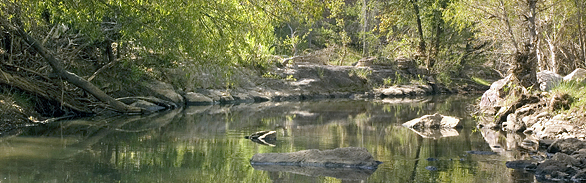
 This perennial stream in extreme southern Arizona offers some of the finest riparian habitat in the region. The watershed supports a diverse array of plant and animal species, some of which are federally endangered or threatened. Sonoita Creek flows southwest through a narrow valley surrounded by mountains, passing through large sections of The Nature Conservancy, state and private land.
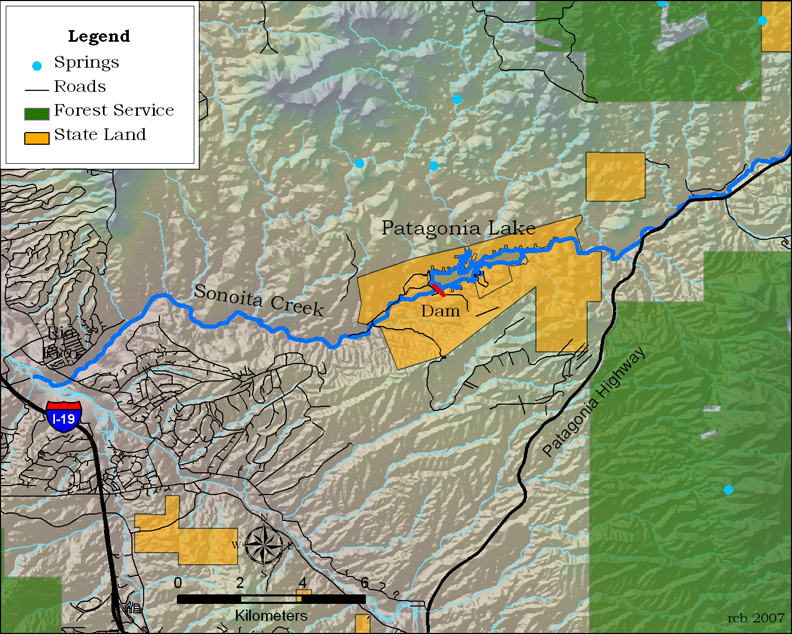
Named for abandoned Pima mission near its headwaters, the creek was dammed in 1968 to form a 265-acre reservoir. Patagonia Lake State Park, which surrounds this 2.5-mile reservoir, is popular for water skiing, fishing, hiking and camping. Perennial stretches of Sonoita Creek, both above and below the reservoir, offer extraordinary opportunities for hiking and birding.
Ecological Importance and Conservation
Upstream of Patagonia Lake are isolated islands of riparian habitat along the creek. Near the town of Patagonia the Nature Conservancy’s Patagonia-Sonoita Creek Preserve is internationally recognized for its diversity of species. Below the dam Sonoita Creek is perennial for about 15 miles, supporting continuous ribbons of lush vegetation along the floodplain terraces in the lower reaches. Water released from the dam passes through Arizona State Trust Land, then flows through the Sonoita Creek State Natural Area. The riparian area also contains wetlands, or ciénegas—some of the most endangered habitats in Arizona.
Some of the tallest and oldest Fremont cottonwood trees in the country—over 100 feet and as much as 130 years old—are found along the drainage. Black walnut, velvet mesquite, velvet ash, netleaf hackberry and several willows also grow here, along with rare and sensitive plants such as the Huachuca water umbel, Santa Cruz striped agave and the Santa Cruz beehive cactus. At just under 4,000 feet elevation, this habitat draws more than 300 species of birds, including green kingfisher, thick-billed kingbird, gray hawk, vermilion flycatcher, violet-crowned hummingbird, black-bellied whistling duck, and rose-throated becard. Northern beardless-tyrannulets are said to be fairly common in the mesquite thickets, and zone-tailed hawk frequent the area in spring and summer, and white-throated sparrows visit in the winter. Over 20 species of flycatchers have been recorded on the preserve, as well as 130 species of butterflies.
The creek supports four native fish, including Sonoran sucker, desert sucker and endangered Gila topminnow. Non-native species such as large-mouth bass and catfish prey upon native species, or compete with them for food. The creek and its surrounding drainage provides important habitat for desert tortoises, rattlesnakes, toads, and frogs. Mammals include bobcat, javelina, white-tail deer, coatimundi, coyote, and the rare mountain lion.
Geohydrology
Flowing between the Santa Rita Mountains to the north and the Canelo Hills, Red Mountain and Patagonia to the south, Sonoita Creek is the southwestern extension of the Ciénega Creek groundwater basin. The streambed alluvium, composed of unconsolidated silt, sand, and gravel deposits, may be up to 90 feet thick. The creek is fed by surface and underground springs; their flow is provided by a main aquifer, as well as several minor ones. As many as five terraces can be identified on the area’s west side adjacent to the Santa Rita Mountains. The numerous washes which dissect the basin-fill terraces dewater them, making the basin-fill dry except where it extends below the level of Sonoita Creek.
Human History
In 1856, following the Gadsden Purchase, the United States Army established Fort Buchanan on the banks of Sonoita Creek. Located on the east slope of Hog Canyon, three miles west of what is now Sonoita, Arizona, the fort was under constant attack by Indians. The army soon abandoned it in favor of a new structure, Fort Crittenden, which was built 1/2 mile east.
The New Mexico and Arizona Railroad paralleled Sonoita Creek for a short distance of its route that connected the Southern Pacific Railroad in Benson with what is now Rio Rico, Arizona. Constructed in 1881 and 1882, it was abandoned in phases between 1927 and 1962. Only about 10 miles of track remains today, operated by the Union Pacific Railroad, joining Rio Rico and Nogales.
Increasing human settlement, beginning in the 1800s, has altered the watercourse with agricultural irrigation and livestock and municipal water use.
Conservation
The Arizona State Parks Board purchased the majority of the land for the natural area in 1993, and acquired several smaller adjacent parcels over the next several years. In 1994 the Trust for Public Land and the Arizona Game and Fish Department acquired 874 acres of ranchland in Coal Mine Canyon, a tributary of Sonoita Creek. The property, in the foothills of the Santa Rita Mountains, was part of the historic 20,000-acre Salero Ranch that was being subdivided and sold as 40-acre ranchettes. This area is managed to protect critical habitat for threatened and endangered species. Spring-fed pools in this side canyon are home to the largest known population of the Gila topminnow. This parcel was added to the Sonoita Creek State Natural Area. The protected area, managed by Arizona State Parks, now spans nearly 9,000 acres and includes several miles of Sonoita Creek. Access to the State Natural Area for birding, wildlife watching, hiking, and equestrian activities is limited and requires a permit.
A portion of the upper watershed is within the first project of The Nature Conservancy in Arizona, the Patagonia-Senoita Creek Preserve. It is sustained by waters released from the Wastewater Treatment plant at the Town of Patagonia. This 740-acre preserve protects a rare riparian forest of Fremont cottonwood and Goodding willow—a once-common forest type that is now quite rare.
Contributing Writers
Jeri Ledbetter and Bob Sejkora.
Photo © Jeri Ledbetter
Links
Visitation
http://www.pr.state.az.us/Parks/parkhtml/patagonia.html#Anchor%20Sonoitahttp://www.pr.state.az.us/Parks/parkhtml/sonoitacreeksna.html
http://www.patagonia-lake.com/
Birds
http://www.birdandhike.com/Bird/Favorite/Patagonia/Patagonia.htm
http://www.sabo.org/birding/santa.htm#paton
Green kingfisher-
http://bna.birds.cornell.edu/review/species/621/articles/introduction
Thick-billed kingbird-
http://bna.birds.cornell.edu/review/species/604/articles/introduction
Gray hawk-
http://bna.birds.cornell.edu/bna/species/652/articles/introduction
Vermilion flycatcher- http://www.birds.cornell.edu/AllAboutBirds/BirdGuide/Vermilion_Flycatcher.html
Violet-crowned hummingbird- http://bna.birds.cornell.edu/review/species/688/articles/introduction
Black-bellied whistling-duck- http://bna.birds.cornell.edu/review/species/578/articles/introduction
Rose-throated becard-
http://identify.whatbird.com/obj/853/_/target.aspx
Northern beardless-tyrannulet- http://identify.whatbird.com/obj/841/overview/Northern_Beardless-Tyrannulet.aspx
Zone-tailed hawk-
http://www.birds.cornell.edu/AllAboutBirds/BirdGuide/Zone-tailed_Hawk_dtl.html
White-throated sparrow-
http://www.birds.cornell.edu/AllAboutBirds/BirdGuide/White-throated_Sparrow.html
Bibliography
- ArizonaNightBuzz website. Sonoita Solitude. http://www.aznightbuzz.com/stories/158558.php, 12/15/07.
- Arizona State Parks, Sonoita Creek State Natural Area, http://www.pr.state.az.us/50thparkhistory/scsnahb.pdf, 12/15/07.
- Go-Arizona.com website. http://go-arizona.com/Patagonia-Lake/, 12/15/07. DesertUSA.com website, http://www.desertusa.com/mag00/aug/stories/pan.html, 12/15/07.
- McGinley, S. Tagging Fish: Monitoring Native Species, University of Arizona College of Agriculture and Life Sciences, http://ag.arizona.edu/pubs/general/
resrpt1999/taggingfish.pdf, 12/15/07. - Trust for Public Land Website. http://www.tpl.org/tier3_cd.cfm?content_item_id=18155&
folder_id=672, 12/15/07.