
Pipe Spring, Pipe Spring National Monument, Arizona
Introduction
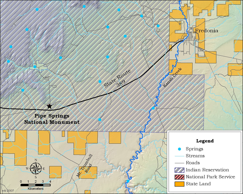 Several springs quietly emerge near the contact of the Navajo Sandstone and Kayenta Formation along the Sevier Fault on the 40-acre Pipe Spring National Monument in north-central Arizona. Enclosed within the North Kaibab Paiute Band Reservation, this monument, managed by the National Park Service, richly preserves a remarkable legacy of the region’s prehistory, history, hydrogeology, and ethnoecology. This small park, located 1/3 mile north of Highway 59, about 14 miles west of Fredonia, is a must-see attraction for anyone interested in the history of human-landscape interactions in the Southwest.
Hydrogeology
Four water sources are recognized in the monument. Main Spring, also called Fort Spring, is the largest. It and Spring Room Spring emerge near or beneath a structure built in the 1870s. Tunnel Spring, located in an adit tunnel, and West Cabin Spring, are nearby. With the exception of West Cabin Spring, all are highly modified. All four emerge at the base of the Vermilion Cliffs, sandstone strata to the north that overlie impermeable shale and mudstone layers. This geological configuration allows surface rain and snowmelt to infiltrate the groundwater aquifer and flow southward along the west side of the Sevier Fault. The springs emerge where fault movement has blocked downward groundwater flow along the fault, or where erosion has removed the impermeable layers.Main Spring flow decreased over the past 40 years, finally ceasing in the summer of 1999; however, the other springs on the Park continue to flow. In 2000 Tunnel Spring discharged 11.3 gallons per minute (gpm) of relatively high quality water, with electrical conductivity of 393 µmhos/cm and 356 mg/L of total dissolved solids. West Cabin Spring had slightly higher water quality, with 322 µmhos/cm specific conductance, 348 mg/L total dissolved solids, a pH of 8.04, a water temperature of 69.5 degrees F, and a flow of 0.75 gpm in May 2005. Since September 2003, the total discharge from all of the springs has been only 10 to 15 gpm.
The demise of Main Spring prompted several hydrology research projects to improve knowledge of the springs and their supporting aquifer, research that was summarized by the National Park Service Water Resources Division in 2007. Margot Truini, who in 1999 described the aquifer and long-term discharge of subbasin springs in detail, analyzed radiocarbon and tritium concentrations that indicated groundwater ages spanning 45 to 9,000 years. Tom Sabol built a groundwater flow model of the capture zones of the springs in 2005.
The National Park Service attributed the loss of the historic flow at Main Spring to groundwater pumping to the north along the Sevier Fault by the North Kaibab Paiute Band, the National Park Service, and the residents of Moccasin, Arizona. Due to the relatively long groundwater residence time for the aquifer, recharge rates are unlikely to balance withdrawal rates. Consequently, dewatered springs are unlikely to recover, and still-flowing springs are at risk of becoming dewatered.
Human History
Pipe Spring and the surrounding lands have long been used and occupied by prehistoric humans. Although some evidence of Paleoindian presence in the region exists in caves and rock shelters, no specific remains of those hunter-gatherers have been detected at Pipe Spring. There is more evidence of Basketmaker and Pueblan Anasazi, who lived near the springs more than a thousand years ago. After about AD 1300 the nomadic Great Basin Paiute Indians camped at the springs during their migrations. They gathered prickly pear fruits, grass seeds, and pinyon nuts, and hunted rabbits and deer in the area. The Navajo Tribe subsequently arrived in the region, resulting in conflicts with the Paiute cultures. For more information on traditional and contemporary cultural resources of Pipe Spring, contact the North Kaibab Paiute Tribal office at (928) 643-7245.The first European visitors to the area were Fathers Francisco Dominguez and Silvestre Veliz de Escalante. They passed within 8 miles of Pipe Spring in 1776 on the return leg of their expedition from Santa Fe, New Mexico to Utah Lake, Utah. The springs were “discovered” in October 1858 by Mormon missionaries headed to the Hopi villages. The area was settled in 1863 as the hub of a ranching operation by Dr. James M. Whitmore, a Texas cattleman. He and his herder, Robert McIntyre, built a temporary shelter, and added ponds, grape vines, and fences only to be killed January 11, 1866 by raiding Navajo Indians.
After Indians drove settlers from the Arizona Strip east of the Virgin River in the latter half of the 1860s, the Utah Militia used Pipe Spring as a camp in 1868 to protect the area from attacks. The “Indian Wars” ended in 1870 when Major John Wesley Powell and Mormon explorer Jacob Hamblin signed a treaty with the Indians at Fort Defiance, Arizona. Hamblin, Powell and Brigham Young, President of the Mormon Church from 1847 until his death in 1877, met by coincidence at Pipe Spring on September 12, 1870. Young subsequently directed the Mormon Church’s southern Utah tithing cattle herd to be moved to Pipe Spring, and ordered a fort to be built to protect settlers, cattle, grazing lands, and water supplies.
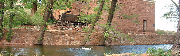
Construction of the fort began in 1870. The first ranch superintendent, Anson P. Winsor, supervised the completion of two two-story stone houses. These structures were connected over Main Spring to create the inner courtyard of the building that became known as Winsor Castle. Gun port windows were added to the structure to protect the “castle” from Indian attack, but were never used. In time, the ranch developed a large herd of cattle and horses and, along with its farming operation, became a regional dairy. The cool spring water was diverted into a trough that ran through one of the rooms. This system maintained the room at a temperature of between 48 and 50 degrees throughout the year. This “spring room” was used for cold storage of dairy products, as well as the production of butter.
In 1871 the first telegraph in Arizona was installed at Pipe Spring. The site also lay on the “Honeymoon Trail,” and many Mormon couples stopped en route to or from the temple in St. George to have their marriages sanctified. In 1888 D. F. Saunders, a non-Mormon cattleman, purchased the ranch, which subsequently changed hands several times.
In May 1923, two months prior to his death, President Warren G. Harding declared the site a national monument to commemorate Western pioneer life. The National Park Service now maintains the ranch much as it was in its heyday, conducting guided tours and demonstrating dairy and other pioneer activities. The Ridge Trail winds up into the foothills behind the Castle and interpretive signs describe the area’s vegetation, geology, and history.
Ecological Importance
Main Spring has a lengthy history of intensive use, and geomorphic and flow alteration, and therefore is not expected to support extensive native assemblages. In contrast, West Cabin Spring is a relatively natural high gradient ciénega (wet meadow), and although it has been subjected to human impacts in the past, the site is more or less functioning naturally.The biota of the Park were inventoried by Oberlin (1998), Grand Canyon Wildlands Council (2002), and Springer et al. (2006). Those studies reported that much of the vegetation around Winsor Castle is dominated by non-native deciduous trees, including Lombardy poplar, Chinese elm, tree of heaven, and other species. The vegetation of the surrounding landscape is dominated by juniper, pinon pine, gray rabbitbrush, skunkbush, and other primarily native plant species. The wetland vegetation of West Cabin Spring consists of 35 plant species on four geomorphic surfaces, including 21 native and 14 non-native species, dominated by Baltic rush, and non-native Bromus diandrus and Kentucky bluegrass.
While the aquatic faunae at the remaining springs in the monument is generally limited, L.E. Stevens found a small population of the aquatic amphipod, Hyallela azteca at Main Spring, prior to its dewatering. Although that population was not detected in subsequent surveys, the amphipod recovered after the National Park Service rewatered this spring by diverting flow from Tunnel Spring. Otherwise, most aquatic invertebrates found in the Main Spring pools are weedy, generalist taxa. Tiger salamanders have been introduced in the west Main Spring pond. There are relatively few aquatic animal species at West Cabin Spring, which is unsurprising due to its small size, isolation, and geomorphic configuration.
Contributing Writers
Larry Stevens and Jeri Ledbetter.
Photo © National Park Service
Links
Visitation
http://www.nps.gov/pisp/http://www.azpbs.org/monumental/pipe.html
Geohydrology
http://wrgis.wr.usgs.gov/docs/wgmt/parks/pispproj/pispproj.htmlhttp://gsa.confex.com/gsa/2002RM/finalprogram/abstract_33945.htm
Human History
http://www2.nature.nps.gov/geology/parks/pisp/index.cfmhttp://www.nps.gov/archive/pisp/adhi/adhit.htm
Bibliography
- Fox, G.L. 2000. The Pipe Spring archeological survey: A Section 110 planning project, Pipe Spring National Monument, Mohave County, Arizona
- Grand Canyon Wildlands Council, Inc. 2002. A hydrological and biological inventory of springs, seeps and ponds of the Arizona Strip, final report. Arizona Water Protection Fund, Phoenix.
- Oberlin, G.E. 1998. Aquatic invertebrate identification project. Pipe Spring National Monument. National Park Service Report, Zion National Park, Springdale.
- Sabol, T.A. Delineation of wellhead and springhead protection areas for the Kaibab Paiute Indian Reservation, Arizona, M.S. thesis, Northern Arizona University, Flagstaff, AZ.
- Springer, A.E., L.E. Stevens, and R. Harms. 2006. Inventory and classification of selected National Park Service springs on the Colorado Plateau: NPS Cooperative Agreement Number CA 1200-99-009. National Park Service, Flagstaff.
- Truini, M. 1999. Geohydrology of Pipe Spring National Monument area, northern Arizona. U.S. Geological Survey Water-Resources Investigations 98-4263.
- Truini, M, J.B. Fleming, and H.A. Pierce. 2004. Preliminary investigation of structural controls of ground-water movement in Pipe Spring National Monument, Arizona. U.S. Geological Survey Scientific Investigations Report 2004-5082.
- U.S. National Park Service. 2007. Summary of flow decline and local hydrogeologic studies, 1969-2007: Pipe Spring National Monument. U.S. National Park Service Water Resources Division Natural Resources Report NPS/NRPC/WRD/NRTR – 2007/365. Ft. Collins.
- Warner, T.J., editor. 1995. The Dominguez Escalante journal: their expedition through Colorado, Utah, Arizona, and New Mexico in 1776. University of Utah Press, Salt Lake City.